
The Banstead Image Library
Wilmot Way Banstead


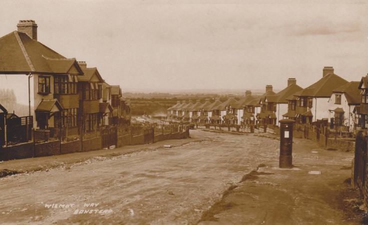
In map of 1868 (1st ed.) the area where Wilmot Way is now was a field with the name of Glebe. It appeared to have a footpath which curved around to join what was then Bolter’s Lane, about one third of the way to the crossroads. The footpath started from what is now the High Street, the end marked by a large tree. This was deemed to be dying and in early 1935 it was cut down. There were proposals to replace the tree with an ornamental island but some elderly residents do not recall any such thing taking place. On record we only seem to have a rather shaky copy of a postcard showing a portion of the tree.
When built there were 115 houses, three of which were single properties, the remainder were three bedroom semi-detached, except for two properties only which were four bed-roomed. Not all houses were built with attached garages although there was allowance on each plot for a garage to be added if required.
As can be seen from the photograph, the roadway, as was common in those days, was not surfaced and records show that the costs of
making the roadway up to highway standards was 18 shillings per foot of frontage. The estimates are quoted in Banstead Quarterly for October 1934. In BQ for January 1936, residents of Wilmot Way, including Lambert Road and Garden Close, were told that the ‘maintenance period’ for the road had now expired and therefore bills for the make-up of the road would shortly be delivered.
Some of the residents may well remember the Muffin Man coming down the road, tray on his head, ringing a hand bell and calling out his business.
Picture added on 17 July 2019 at 18:33
This picture is in the following groups
Roads (all)
Roads (all)
External Links
Banstead History
Banstead History
Banstead